Monday, May 20, 2013

Birds of LPPCHEA

On Saturday, May 17, 2013, PAWCZMS employees Mark Clee Marquez, Renz Marion Gamido and Chris Villarin, together with Atty. Gilbert Gordove, came by LPPCHEA to document and take pictures of wild and migratory birds in the area.  Here are some of the pictures taken by the blogger/author:


 Egrets aboard a bamboo raft

A flock of Black-Crown Night Heron

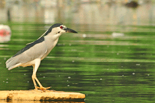
Black-Crown Night Heron on a floating debris

Black-winged Stilts

Heron readying for flight

The prized Philippine Ducks of LPPCHEA

Little Egret

Migratory birds frequent LPPCHEA because of the extensive mangrove cover of the area, the long stretch of mudflats and salt marshes, and its calm lagoons.  It also happens that LPPCHEA lies along the East Asian – Australasian Flyway, making it an important stop for migrating birds coming from as far as Siberia.

Dubbed as the last coastal frontier of Manila, LPPCHEA is an ideal weekend getaway for families, friends, and groups interested in wildlife photography, scientific research or simply communing with nature, all without leaving the metro.

Open to the public, those interested in visiting the place may coordinate with LPPCHEA Office at 435-2410 and secure a Visitor's Application Form. 


(Pictures taken by Mark Clee Marquez and Atty. Gilbert Gordove will be posted soon.)


Sunday, May 19, 2013

Likasyaman Newsletter

Likasyaman is the official publication of PAWCZMS, DENR-NCR.  It is a one-page newsletter containing updates on the activities of PAWD, CMMD and LPPCHEA.  Started only last December, 2012, Likasyaman has come out with several issues.

Copy of the previous issues of the Likasyaman may be viewed here:


About PAWCZMS

PROTECTED AREAS, WILDLIFE AND COASTAL ZONE MANAGEMENT SERVICE (PAWCZMS)

The Protected Areas, Wildlife and Coastal Zone Management Service (PAWCZMS) of the Department of Environment and Natural Resources-National Capital Region (DENR-NCR) is primarily in charge with the preparation of action programs and implementation strategies on conservation and protection of wildlife, coastal and marine resources of the region. It has two divisions and one special unit under it. These are Protected Areas and Wildlife Division (PAWD); Coastal and Marine Management Division (CMMD); and the Las Piñas-Parañaque Critical Habitat and Ecotourism Area (LPPCHEA).

PROTECTED AREAS AND WILDLIFE DIVISION (PAWD)

PAWD was created pursuant to DAO 1992-25 (Section 36) which provides for the creation of a PAWD in each region where protected areas have been established.

The Division coordinates and monitors activities related to protected area management, wildlife resources conservation and law enforcement within the region.

Under the wildlife conservation efforts, the PAWD is the one primarily in charge in the regulation of wildlife trading, breeding and possession. They process the issuance of the following permits following the procedures and requirements provided for in Republic Act 9147 (Wildlife Resources Conservation and Protection Act):

  1. Certificate of Wildlife Registration (CWR); 
  2. Wildlife Farm Permit (WFP); 
  3. Wildlife Import/Export Certificate (WIC/WEC); 
  4. Local Transport Permit (LTP); 
  5. Wildlife Special Use Permit (WSUP). 
Another work of the PAWD in relation to wildlife conservation and protection is ensuring the strict implementation of existing laws, rules and regulations on wildlife (law enforcement). This is done through the conduct of surveillance and operations tracking illegal trading of wildlife and prosecuting its perpetuators, in partnership with other law enforcement agencies and deputized Wildlife Enforcement Officers (WEOs).

The Wildlife Traffic Monitoring Units (WTMU) required created in strategic air and seaports pursuant to Republic Act 9147 is being supervised by this Division. The primary function of the WTMUs is to ensure the strict compliance and effective implementation of all existing wildlife laws, rules and regulations, including pertinent international agreements.

COASTAL AND MARINE MANAGEMENT DIVISION (CMMD)

The CMMD was established through DAO 2002-08 which provides for its creation in regions where there exist coastal areas. Its tasks, among others, are:

  1. Prepares action programs and implementation strategies on coastal and marine environment; 
  2. Provides technical assistance to LGUs, NGOs, and PO in the Region; 
  3. Coordinates with the LGUs and other concerned sectors and agencies in the creation of task forces on coastal and marine environment; and 
  4. Conducts information, education and communication activities, as well as capability-building on coastal and marine management concepts, tools and technologies. 
The aforecited tasks are carried out by the CMMD through the implementation of programs and projects involving (1) habitat and resources restoration, (2) provision of technical assistance to LGUs, NGOs and POs in the conduct of training, workshops, seminars pertaining to integrated coastal resource management, (3) spearheading of environmental events and celebrations focusing on coastal and marine such as the celebration of Month of the Ocean, World Water Day and International Coastal Cleanup to promote awareness, and (4) formation and operationalization of Coastal Law Enforcement Alliance in the NCR (CLEAR-NCR). 

The CLEAR-NCR was established to have a more coordinated manner of coastal law enforcement and environmental campaign in Manila Bay. It is composed of of 5 coastal LGUs, 7 NGAs (PPA, PCG, MARINA, PNP-Maritime, BFAR, LLDA, EMB), 2 NGOs (101st PCGA & Manila Yatch Club) 3 POs (City FARMCs of Navotas, Las Pinas and Paranaque).

The overarching thrust of CMMD in undertaking these programs and projects is making coastal communities resilient to climate change effects. Studies on climate change show that coastal communities are predicted to bear the brunt of the climate change effects. Habitat restoration efforts, capacity-building for LGUs and the people to undertake an integrated coastal resource management approach, and raising their awareness on various coastal and marine management issues would help them mitigate and adapt to climate change effects.

Reforestation of existing mangrove areas and restoring mangrove forests would not only help reduce green house gases from the atmosphere. It also forms natural barriers which provide shore protection both under normal sea conditions and during typhoons. Because of their intricately entangled above-ground root systems, mangroves protect shorelines during storms and typhoons by absorbing wave energy and reducing the velocity of water passing through the root barrier. Mangroves also facilitate soil accretion thus stabilizing the coastline by catching sediment washed downstream.

LAS PIÑAS-PARAÑAQUE CRITICAL HABITAT AND ECOTOURISM AREA (LPPCHEA)

a. Legal Bases
The Las Piñas-Parañaque Critical Habitat and Ecotourism Area (LPPCHEA) was established by virtue of Presidential Proclamation No. 1412 dated April 22, 2007, which was amended on January 31, 2008 by Presidential Proclamation 1412-A.

P.P. 1412-A directs all relevant departments and instrumentalities under the executive branch to ensure the preservation of existing mangrove, mudflats and ecosystems in the area that supports natural ecological functions. It also directs the DENR to convene and chair a Manila Bay Critical Habitat Management Council.

b. Rationale for its Declaration as a Critical Habitat

Its declaration as a critical habitat was based on the findings that it hosts at least 5,000 heads of diverse species of birds both migratory and residents. Most significant is the presence in the area of at least 1% of the population of Greenshank and 10% of the population of Black-winged Stilt within the East Asian-Australasian Flyway.

Moreover, its proclamation is consistent with and in support of Philippine commitments to international conventions, such as:

  1. Convention on Migratory Species (CMS,1994); 
  2. Convention on Biological Diversity (CBD,1992); 
  3. Convention on International Trade in Endangered Species of Wild Fauna and Flora (CITES); 
  4. International Convention on the Conservation of Wetlands (RAMSAR Convention). 
c. Location and Significance of the AreaThe LPPCHEA is located on the western side of the Aguinaldo Highway (Coastal Road) and is bounded on the north by the Paraňaque River and on the South by the Las Piňas River. It covers an area of 175 hectares consisting of mangroves, mudflats and diverse avifauna. It is the first critical habitat established in the country. 

The LPPCHEA is said to be “the last coastal frontier of Metro Manila”. It is the only coastal ecosystem along Manila Bay with high diversity of plants and birds. For this, it has become a showcase for students, researchers and nature lovers.
Manila Bay is one of the most important coastal wetlands hosting more waterbirds than any other areas in the Philippines. With its degradation, birdcounts also decline which can be attributed to the loss of habitats - mangrove areas were converted into fishponds while others are converted into commercial, industrial and residential areas.

d. Wildlife and Natural Resources Found in the Area

Birds
LPPCHEA harbors more than 5,000 heads of birds at one time. To date 80 species of birds has been recorded in the area, around 50% of which are migratory. Rare species such as Pied Avocet and Grey-tailed Tattler invited attention of birders to the area. The sightings of the Siberian Rubythroat triggered interests among bird enthusiasts both foreign and local.

The area is also known for the Philippine Duck, an endemic and vulnerable species. Hundreds of them could be observed during migration season when they mingle with migratory species. Another species worthy in the area is the endangered Chinese Egret.

Mangroves
Another important element of the LPPCHEA is the mangrove forest – the thickest stands among the mangrove areas within Manila Bay covering 30 hectares. There are 8 species of mangroves in the area, namely: bungalon, bakauan babae, pototan, kulasi, pagatpat, bangkau, banalo and buta-buta.

Mangroves serve as roosting areas for birds, provide spawning grounds for marine life, serve as natural barriers to storm surges and filter pollutants from water.


Mudflats
Taken for granted are the mudflats which people thought only as “burak” and useless. LPPCHEA has 114 hectares of mudflats which serve as feeding grounds for the birds. As the water recedes during low tide, it exposes small invertebrates that serve as food for the birds. Thus, many birds could be observed during low tides in the early morning and late afternoon.


: